ROSE: Reflection Ocean Seismic Experiment
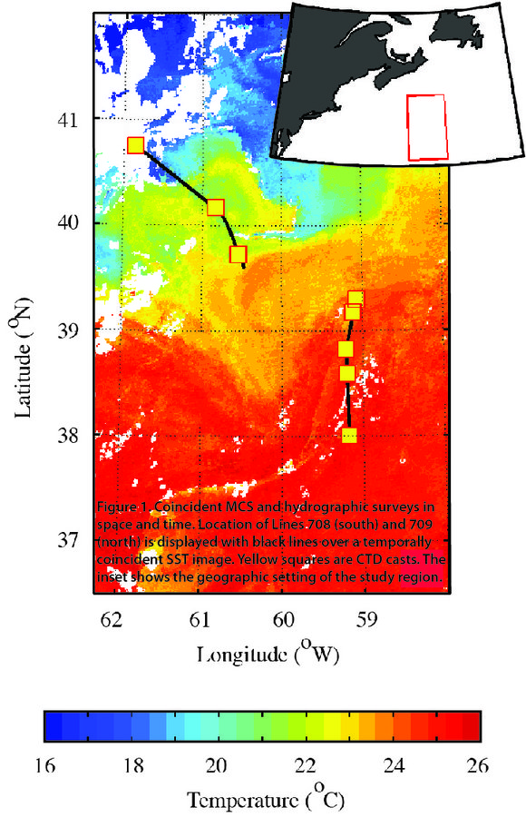
This experiment was done during 2007 R/V Endeavor cruise EN438 along selected UNCLOS MCS lines (Figure 1). The combined MCS and XBT/CTD profiles
Funded by the NSERC Special Research Opportunities fund
In addition to the ROSE, we carried out two physical oceanography experiments coincident with our MCS solid-earth studies. These are ALEUT: Alaska Langseth Experiment to Understand the megaThrust carried out in 2011 and R2T: Ridge to Trench Experiment Across the Juan de Fuca Plate completed in 2012. Information about the physical oceanography component of these experiments is given on this page after the ROSE description.
Reflection Ocean Seismic Experiment (ROSE). This experiment was done during 2007 R/V Endeavor cruise EN438 along selected UNCLOS MCS lines (Figure 1). The combined MCS and XBT/CTD profiles provide a special opportunity to obtain, for the first time, detailed depth-images of the Gulf Stream offshore Nova Scotia, its meanders, warm core rings, water mass boundaries, and other features that have important societal implications. Warm water carried by the Gulf Stream is a key component of the global climate system and is a source of heat energy that drives major storms on the Eastern Seaboard. Warm core rings transport warm water to the Scotian Shelf, changing the thermal and saline properties of shelf waters, and affecting East Coast weather.
The development of seismic oceanography requires direct comparison of seismic data to high-resolution oceanographic measurements over long horizontal scales. In this experiment, we compare multichannel seismic (MCS) reflection images to 300 km of spatially-coincident, high-resolution (<1 km spaced) expendable bathythermograph (XBT) surveys that were collected near a frontal region of the Gulf Stream. Fronts, eddies, tendrils, and interleaving were among the features identified in both data sets. In some cases, identification of features would be difficult if only hydrographic data were collected at conventional spatial scales. Comparing MCS reflection images with others derived purely from hydrographic data reveal many similarities and show that interleaving can be clearly identified with seismic methods. Varied time lags between MCS and hydrographic data collection identified the need for the separation between collecting both data sets to be short (i.e. hours to days), with advective processes and decorrelation time scales of desired features affecting acceptable sampling strategies.

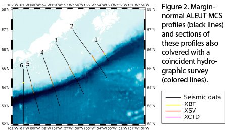
ALEUT: Alaska Langseth Experiment to Understand the megaThrust. Circulation in the Gulf of Alaska (GOA) is dominated by two current systems, the cyclonic subarctic gyre in the basin and the Alaska Coastal Current (ACC) on the continental shelf. At the head of the GOA, the ACC turns southwestward following the shelf-break and forms the Alaska Stream. The GOA supports a rich ecosystem, including numerous species of fish, marine mammals and seabirds. Significant amount of nutrients in the GOA is supplied by strong mechanisms of cross-shelf exchange and mixing, which include episodic upwelling, eddies and tidal mixing combined with bathymetric steering. During the ALEUT solid-earth experiment we carried out an add-on seismic oceanography investigation (Figure 2). The main goal of our seismic oceanography investigation is to image the fine structure generated by the mixing processes along the shelf-break. The seismic data will be compared with temperature, sound speed and salinity profiles simultaneously acquired with XBT, XSV and XCTD probes.We used 125 XBTs, 83 XSVs and 12 XCTDs. XBTs and XSVs were deployed in an alternating order. Along Lines 3, 4 and 5 the XBT and XSV pairs were deployed as close as possible, at ~0.6 km spacing. In order to continuously sample for ~60 km along the slope, the distance between the XBT/XSV pairs was set at ~3.5 km. For Lines 1, 2 and 6, the spacing between all probes was as short as possible, ~0.6 km.

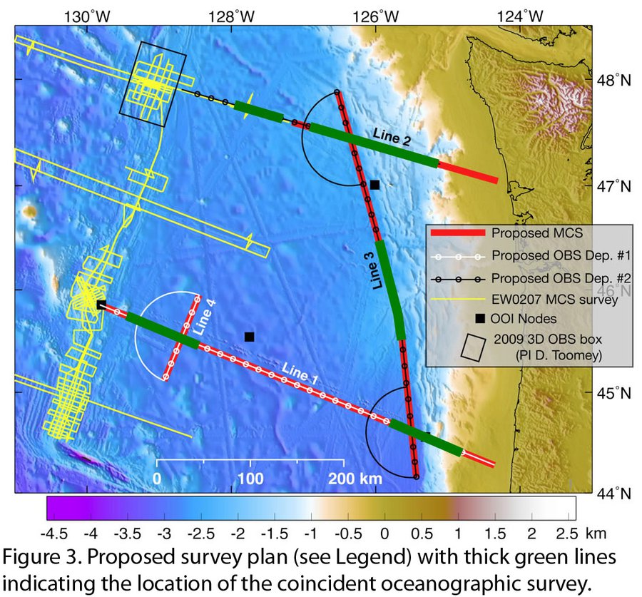
Juan de Fuca Ridge2Trench Experiment. The Juan de Fuca Ridge2Trench survey has been carried out in the Cascadia Basin (Figure 3). The water column covering the Cascadia Basin is affected by several currents that influence regional patterns. As the North Pacific Current approaches North America from the central Pacific, it splits into the north-flowing Alaskan Current and the south-directed California Current. Different water masses can be identified in the water column: the California Current up to ~500 m depth; the Subarctic Intermediate Water, between 900 m and 1900 m ; the Cascadia Basin Bottom Water and the Cascadia Deep Water below 2000 m. These water masses have different temperature and salinity properties. A geophysical survey carried out 10 years ago in the same area recorded strong reflectivity within the top 1000 m of the water column.
There were two research vessels involved in the Juan de Fuca Ridge2Trench survey: R/V Marcus Langseth, which was used to carry out the MCS data acquisition and R/V Oceanus, which was used for the OBS instruments. We used R/V Langseth to also acquire XBT and XSV data simultaneously with the seismic acquisition. Additionally, we used R/V Oceanus to carry out CTD space-coincident casts (not in time) with the seismic acquisition. CTD casts provide data that can be used to detect the thermohaline structure with higher resolution than with the expendable probes and they provide information on the temperature-salinity relationship in the area. 378 oceanographic probes were deployed simultaneously to the seismic data acquisition: (1) 237 XBT-T5, 10 boxes (1box=12probes) bought by Dalhousie University, 5 by the Spanish Scientific Research Council (CSIC) and 6 by the MARCOM/ Canada National Defence; (2) 120 XSV-02 from the MARCOM/ Canada National Defence; (3) 21 XBT-T7, 1 box from the MARCOM/ Canada National Defence and 9 XBT-T7 provided from the RV Langseth. The XBTs launched along Line 2 had 1 km spacing in the deepest section and ~3 km spacing in the section over the continental slope. Along Line 1 and Line 3 the probes were deployed by alternating between XBTs with XSVs, with 1 km spacing. Two plastic plumes were used for the deployment of the oceanographic probes to launch them as far away as possible from the ship, with the purpose of preventing the wire of the expendable probes from getting stacked in the airguns or the streamer array. This system is not fully efficient and 10% of the probe wires were broken, however without the plumes, all the probes would have failed. All the successful probes were deployed using the port plume because it was longer and deployed the wires further away from the seismic arrays.

Data from all three experiments are currently being analyzed.