3D MCS offshore New Jersey: Seismic geomorphology and Neogene sea-level changes
In collaboration with Lamont-Doherty Earth Obs. of Columbia Univ., Rutgers Univ., and Univ. of Texas Inst. for Geophysics
Funded by the United States National Science Foundation
The NJ margin has for decades been recognized as among the best siliciclastic passive margins for elucidating the timing/amplitude of eustatic change during the “Ice House” period of Earth history, when glacioeustatic changes shaped continental margin sediment sections around the world. A transect strategy adopted by the international scientific ocean drilling community has been used to study this interval at shallow-water settings offshore NJ, New Zealand and the Bahamas that were dominated by prograding clinoforms. 3D seismic imaging is now a viable tool for the research community, ready to be applied to the NJ margin to put these sampled records in a spatially accurate, stratigraphically meaningful context. Such imagery will allow researchers to map sequences around Exp313 sites with a resolution and confidence previously unattainable, and to analyze their spatial/temporal evolution. Long-awaited objectives include: 1) establishing the impact of known Ice House base-level changes on the stratigraphic record; 2) providing greater understanding of the response of near-shore environments to changes in elevation of global sea level (with special relevance to the current relentless rise), and 3) determining the amplitudes/timing of global sea-level changes during the mid-Cenozoic, which should help humanity put anthropogenic base-level change in a proper long-term context.
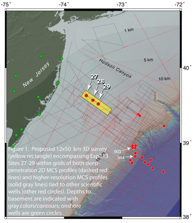
For the general benefit of a broad user community of scientists, educators and students, we proposed to coordinate the use of R/V Marcus Langseth to acquire a 3D seismic volume encompassing the three IODP Expedition 313 drillsites on the inner-middle shelf of the New Jersey (NJ) continental margin (Figure 1). Exp313, the latest chapter in the multi-decade Mid Atlantic Transect, represents the community’s best opportunity to link excellently sampled/logged late Paleogene-Neogene prograding clinoforms to state-of-the-art 3D images. The primary goal of this proposal is to constrain the complex forcing functions tying evolution and preservation of the margin stratigraphic record to base-level changes. These processes include eustasy, climatic and paleo-oceanographic variations, tectonism, compaction and rates of sediment supply. Exp313 borehole data will provide lithostratigraphy, geochronology and paleobathymetry. Geomorphology revealed by coherency in horizontal (travel time) slices within the volume (among other 3D imaging tools) will identify diagnostic features such as river systems, shorelines, delta channels, sediment failure scars, etc., none of which can be resolved in existing 2D seismic data to the degree required to map shifting shallow-water depositional settings in the vicinity of clinoform rollovers. Embracing a community-based strategy, the co-PIs will manage planning, acquisition and data processing up to the point of an interpretable 3D volume. This will entail a pre-cruise planning workshop, hands-on training for young scientists at sea, and rapid turn-around of the data by a commercial processor. Data will be made available to the engaged scientific community to use as the foundation of follow-on, PI-driven proposals that improve understanding of factors shaping the NJ margin in particular, and that imprint the sedimentary record at continental margins in general. The scientific parties of several ocean drilling expeditions and outcrop specialists of shallow water systems are two groups certain to want to compare their research experience with the ground-truth these data will provide.
The community will be engaged in 3 ways.
- A pre-cruise workshop will review the scientific payoff that 3D seismic-core-log integration can provide, and enable attendees to help shape acquisition and data processing details that optimize this goal;
- 12 bunks aboard Langseth will be reserved for student/postdoc/ young scientist volunteers to acquaint each with 3D acquisition and the myriad activities that comprise a research cruise; and
- A post-cruise workshop will identify community-based avenues for analysis/interpretation of the processed 3D volume and integration with Exp313 results.
The 3D images will very likely become an integral part of IODP outreach. Lamont-Doherty Earth Observatory and the University of Texas Institute for Geophysics have collaborative NSF grants to archive marine seismic data collected with NSF support. The raw field data will be delivered to the LDEO facility immediately after acquisition, and a fully processed 3D data ‘volume’ will be sent to the UTIG facility ~5 months after that, with the expectation that these data will become a showcase for how such sub-seafloor imaging can inform the understanding of stratigraphic evolution at continental margins.